


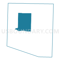
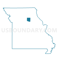
Huntsville Voting District, Randolph County, Missouri
About
Outline

Summary
| Unique Area Identifier | 609513 |
| Name | Huntsville Voting District |
| County | Randolph County |
| State | Missouri |
| Area (square miles) | 49.83 |
| Land Area (square miles) | 49.65 |
| Water Area (square miles) | 0.17 |
| % of Land Area | 99.65 |
| % of Water Area | 0.35 |
| Latitude of the Internal Point | 39.49039950 |
| Longtitude of the Internal Point | -92.55353530 |
Maps

Graphs
Select a template below for downloading or customizing gragh for Huntsville Voting District, Randolph County, Missouri


Neighbors
Neighoring Voting District (by Name) Neighboring Voting District on the Map
- Cairo Voting District, Randolph County, MO
- Clifton Hill Voting District, Randolph County, MO
- Darksville Voting District, Randolph County, MO
- Jacksonville Voting District, Randolph County, MO
- North Sugar Creek Voting District, Randolph County, MO
- Salt Springs Voting District, Randolph County, MO
- South Sugar Creek Voting District, Randolph County, MO
- Thomas Hill Voting District, Randolph County, MO
Top 10 Neighboring County Subdivision (by Population) Neighboring County Subdivision on the Map
- South Sugar Creek township, Randolph County, MO (7,499)
- North Sugar Creek township, Randolph County, MO (5,994)
- Salt Springs township, Randolph County, MO (2,873)
- Cairo township, Randolph County, MO (1,257)
- Jackson township, Randolph County, MO (411)
- Clifton township, Randolph County, MO (241)
- Chariton township, Randolph County, MO (238)